We chose our starting point carefully: the place where the need is most immediate and progress is measurable fastest. The goal was never limited to that starting point — it's all 139,000 km².
The Scale
The land can't wait.
139,000 km²of Ukrainian territory contaminated with landmines and unexploded ordnance
€35Bestimated cost to fully clear it
10–70 yrsestimated clearance timeline at today's pace
€10.1B+GDP cost to Ukraine every year the land stays blocked
Behind those numbers are farmers who can't work their own fields, families who can't return home, and a national economy that can't recover the land it depends on. Clearance can only move as fast as it knows where to look — and right now, detection and mapping are the bottleneck.
The Cost of Delay
The "10–70 yrs" above is Ukraine's own National Mine Action Strategy range, at today's pace. SubTerra doesn't change the size of the problem — it changes how fast it can be found and mapped. Here's what that speed is worth in years, across the full 139,000 km² of contaminated territory: farmland first, then roads, forests, and everything else that can be mapped from the air, addressed as access allows — both in currently-reachable areas now, and beyond them over time.
Today's pace 198,571 ha/yr · fully cleared in 70.0 yrs2× faster 397,143 ha/yr · fully cleared in 35.0 yrs4× faster 794,286 ha/yr · fully cleared in 17.5 yrs6× faster 1,191,429 ha/yr · fully cleared in 11.67 yrs8× faster 1,588,571 ha/yr · fully cleared in 8.75 yrs — beats the 10-yr case10× faster 1,985,714 ha/yr · fully cleared in 7.0 yrs — beats the 10-yr case
At today's pace, full clearance takes 70 years — the national strategy's own worst case. At 6× or faster, SubTerra-augmented clearance beats the strategy's own best case (10 years).
Why speed matters economically: the World Bank / Ukraine Ministry of Economy put total clearance cost at roughly €35 billion, and the Tony Blair Institute estimates contaminated land currently costs Ukraine €10.1 billion or more in lost GDP every year it remains unresolved. Every year clearance is pulled forward is a year that €10.1B+ annual drag doesn't apply.
Illustrative model. Total: 139,000 km² of contaminated territory (UNMAS / Government of Ukraine estimate) — farmland, roads, forests, and other terrain, addressed as access and mapping allow, both in currently-accessible areas and, over time, beyond them. "Today's pace" and the 10– and 70-year reference points reflect Ukraine's National Mine Action Strategy and independent projections, already cited above. Source: SubTerra Intelligence.
Why This, Personally
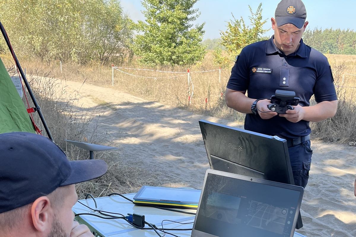
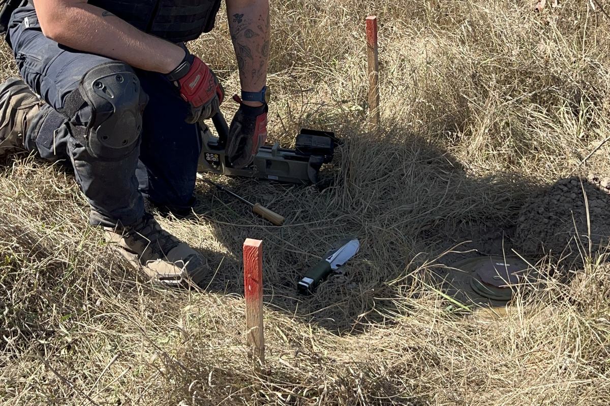
"I've stood in the minefields this platform is built for. In September 2023, I traveled to Kyiv with Denmark's EIFO to meet Ukraine's State Emergency Service (SESU) — and into an active minefield with their deminers, to see clearance done today: meter by meter, on foot, by hand. That's the problem this platform is built to solve."
— Jesper Wieder, Founder
A SESU deminer operating field detection equipment, September 2023.An unexploded mine, marked and being carefully excavated by hand.
The Scope
Farmland first. All 139,000 km², over time.
Ukraine has an estimated 139,000 km² of contaminated territory, and mapping all of it is the goal. We start with agricultural land, because that's where the need is most immediate and where we can prove the platform fastest — farmers who can't work their fields, families who can't return home, an economy that can't recover. From there, the same platform extends to roads, forests, and every other terrain that can be mapped from the air.
This isn't a smaller ambition — it's the fastest path to real, verified impact.
How the war resolves doesn't change the mission. If it ends, land that isn't reachable today opens up, and we extend there. If it continues, more land becomes contaminated — and that's more of the same 139,000 km² total we're already working toward. Starting with farmland lets us prove the platform now, build the ground-truth library that makes Genetix Software more capable over time, and put land back into use for the people who depend on it — while scaling toward the rest.
Why It Matters Beyond Ukraine
Cleared land is measurable progress.
Safety, food security, economic recovery, and institutional stability all sit downstream of one precondition: land that's safe to use. We're scoped to the seven UN Sustainable Development Goals where that connection is direct, structural, and already demonstrable.
2
Zero Hunger
Ukraine's agricultural export capacity is directly constrained by blocked farmland — an estimated 2.0 million hectares, worth roughly €2 billion in foregone export value every year.
3
Good Health & Well-Being
The most immediate outcome of the platform's work — every accurate detection is a prevented death or injury.
8
Decent Work & Economic Growth
Cleared land is the precondition for economic activity to resume — agriculture, construction, reconstruction.
9
Industry, Innovation & Infrastructure
A hardware-agnostic sensor fusion architecture paired with a deterministic intelligence layer — genuine innovation in a field that has lacked it.
15
Life on Land
Unexploded ordnance degrades soil and can leach harmful chemicals over time. Removing it is direct environmental remediation.
16
Peace, Justice & Strong Institutions
Mine action is formally recognised within UN post-conflict recovery and peacebuilding frameworks, explicitly named under Target 16.1.
17
Partnerships for the Goals
Three specialised companies operating as a single coordinated platform, working alongside the wider mine-action field.
This isn't a problem that shrinks as it gets solved — new conflicts create new contaminated land elsewhere, which is part of why the global UXO and landmine detection market is valued at €7.3 billion by 2030. The need is already recognized at scale: the Howard G. Buffett Foundation alone has committed over €161 million to Ukraine demining to date.
Sources
139,000 km² and €35B clearance cost — UN Mine Action Service (UNMAS) / Government of Ukraine, and World Bank / Ukraine Ministry of Economy estimates, 2025–2026. 10–70yr clearance timeline — Ukraine National Mine Action Strategy and independent projections. €10.1B+/yr GDP cost — Tony Blair Institute. €7.3B global market by 2030 — Research and Markets, 2025. ~2.0M ha of potentially mined farmland — Ukraine Ministry of Agrarian Policy & Food (Minister Vitaliy Koval), October 2025, corroborated by GLOBSEC; the ~€2B/yr export-value figure is derived from that hectare estimate and Ukraine's 2024 agricultural export value per cultivated hectare.
See who's building this.
SubTerra Intelligence is a joint venture between three companies who already build this technology.